USGS Home - www.usgs.gov NASA - National Aeronautics and Space Administration NOAA - National Oceanographic and Atmospheric Administration National Park Service
Coastal and Marine Geology Program

Mapping Coastal Change Hazards

Hurricane Dennis, 1999: North Carolina Outer Banks - Rodanthe, NC

Introduction Hazard Scale First Line of Defense Northeaster Hurricane El Niño Photos
Hurricane Dennis, 1999:     Rodanthe, NC  |  Buxton, NC

Below at left is a map of lidar-mapped topography near Rodanthe, NC, after Hurricane Dennis. The purple is water; hot colors indicate higher elevations (see scale). Note red rectangles which represent houses that survived the storm. The white rectangles are houses destroyed during the storm, found by comparing the pre- and post-storm lidar surveys.

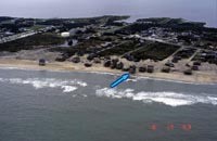
The photographs to the right of the lidar map both show the same house (blue arrow) viewed from the ground and from the air. The position of this house is also noted (blue arrow) on the lidar topographic map. Click on either of the photographs to view a larger version.

map-view plot of lidar elevation data along the shore of Rodanthe, North Carolina, showing positions of houses destroyed by Hurricane Dennis photograph of beach houses in Rodanthe, North Carolina

oblique aerial photograph of Rodanthe, North Carolina

Introduction Hazard Scale First Line of Defense Northeaster Hurricane El Niño Photos
Hurricane Dennis, 1999:     Rodanthe, NC  |  Buxton, NC


Coastal and Marine Geology Program > Center for Coastal Geology > Hurricane and Extreme Storm Impact Studies > Mapping Coastal Change Hazards > Hurricane Dennis, 1999: North Carolina Outer Banks > Rodanthe, NC

FirstGov.gov U. S. Department of the Interior | U.S. Geological Survey
Coastal and Marine Geology Program

email Feedback | USGS privacy policy & disclaimers

This page is http://coastal.er.usgs.gov/hurricanes/mappingchange/rodanthe.html
Updated May 07, 2001 @ 04:18 PM (THF)